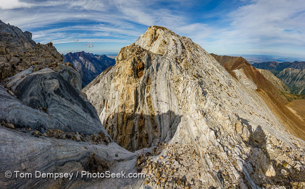
Oregon, USA
Index to this page: Oregon Coast
( Cannon Beach , Ecola SP , Seaside , sand patterns , Cape Meares Lighthouse ,
Three Arch Rocks , Oregon Coast Aquarium at Newport , eagles , Steller sea lions
, Heceta Lighthouse , Florence )
,
Crater Lake , Columbia
River Gorge , Champoeg SP , Umpqua
Waterfalls & Hot Springs
Photographs Copyright 2004-2008 by Tom
Dempsey.
Last
updated February 25, 2008.

Custom Print Prices. ~ Send
comments to: Tom@photoseek.com
Cannon Beach
Below: The pounding Pacific Ocean has eroded a bluff to
create Haystack Rock, a 235-foot (72-meter) tall sea stack (coastal
rock monolith), on Cannon Beach, on the Oregon coast. Haystack Rock is
part of the Tolovana Beach State Recreation Site and is managed by
Oregon Parks and Recreation below the mean high water (MHW) level, and
above the MHW level by the Oregon Islands National Wildlife Refuge of
the United States Fish and Wildlife Service.
Left: A wave crashes against rocks near two sea pillars at Cannon Beach.
Below: A big wave explodes agains a rock.
Left: A wave crashes against rocks at sunset at Cannon Beach.
Below: The sun silhouettes sea pillars and Haystack Rock, which are reflected in wet wavy sand at Cannon Beach.
Left: The orange sun sets behind rocks at Cannon Beach.
Below: The yellow-orange sun sets behind rocks at Cannon Beach.
Left: A silhouetted person admires the orange sun setting behind Haystack Rock at Cannon Beach.
Below: Silhouetted people admire the orange sun setting behind Haystack Rock and other sea stacks at Cannon Beach.
Left: The sun sets behind rocks at Cannon Beach as the tide washes in.
Below: Wet wavy rumpled sand reflects Haystack Rock (235 feet high) at sunset on Cannon Beach.
Left: Driftwood points at sea stacks including Haystack Rock, accessible from
Tolovana Beach State Recreation Site, at the town of Cannon Beach,
Oregon.
Below: In the dim light of dusk, the tide blurs over rocks beneath sea pillars at Cannon Beach.
Left: A photographer captures rock columns and waves at sunset at Cannon Beach.
Below: Sea stacks and crashing waves are silhouetted against the sun at Cannon Beach.

Left: The sky glows magenta at late sunset behind rock needles reflected in wet sand at Cannon
Beach.
Left: A wave crashes against rocks as the sky glows orange behind rock pillars reflected in wet sand at sunset on Cannon Beach.
Below: A photographer studies two rock monuments at sunset at Cannon Beach.
Left: In the dim light of dusk, a crashing wave blurs beneath sea pillars reflected in wet sand at Cannon Beach.
Below: In the dim light of dusk, the tide blurs beneath sea pillars at Cannon Beach.
Above: Two people enjoy a beautiful walk beneath Haystack Rock (235 feet high) at sunset on Cannon Beach. The tide has washed in a strand of bull kelp in the foreground.
Ecola State Park
Above: Ecola State Park offers picnic
tables and classic views of sea stacks, including Haystack Rock, rising
above crashing waves on the Oregon coast, adjacent to the town of Cannon Beach.
Left: Waves roll in from the Pacific Ocean and erode sea stacks at Cannon Beach.
Below: Easy trails in Ecola State Park offer classic views of
sea stacks, including Haystack Rock, rising above crashing waves on the
Oregon coast.
Above: Ecola State Park provides classic views of sea stacks, including Haystack Rock (235 feet high) on the Oregon coast.

Above: Haystack Rock seen from Ecola State Park, near the
town of Cannon Beach.
Seaside
Left: A statue of Lewis and Clark commemorates the end of their trail 1805-1806, at the present-day Prom at Seaside, Oregon.
Below: A gull claims the Lewis and Clark statue.
Sand Patterns
Left: The retreating tide has sculpted these abstract shapes in the beach of Seaside, Oregon.
Left: Retreating surf has left these subtle abstract shapes in the beach of Seaside, Oregon.
Below: The last wave of high tide left these small waves of brown
algae foam on the sand at Seaside, on the Oregon coast, USA. It
resembles a fractal pattern.
Cape Meares near Oceanside
Left: Cape Meares Lighthouse was commissioned in 1890,
decommissioned in 1963 and is now maintained by a non-profit
organization. The tower stands 38 feet high and is the shortest
lighthouse in Oregon. It is located at Cape Meares State Scenic
Viewpoint, on the Oregon coast, USA. The lighthouse's first order
Fresnel lens (pronounced "fraynel") was made in Paris, France, shipped
around South America's Cape Horn to Cape Meares and then hauled 217
feet up the cliff for installation.
Below: The Octopus Tree is a large Sitka Spruce (Picea sitchensis)
branched like a candelabra, at Cape Meares State Scenic Viewpoint,
Oregon. Its base circumference is more than 50 feet. Native Americans,
who have lived here for 3000 years, call this the Council Tree. Indian
legend says this tree was used for supporting a canoe which held their
dead, an ancient custom. Another theory is that coastal winds warped
the tree.
Above: Waves march from the Pacific Ocean past Three Arch Rocks National Wildlife Refuge, as seen from Cape Meares State
Park, a few miles north of the town of Oceanside, Oregon. (This panorama is stitched from three images.)
Designated as the first National Wildlife Refuge west of the
Mississippi River, Three Arch Rocks Refuge lies a half mile offshore
of Oceanside. One of the Oregon coast's best-known
landmarks, the refuge consists of three large and six smaller rocks
totaling 15 acres. The refuge is one of the smallest designated
Wilderness Areas in the country. The rocks provide habitat for Oregon's
largest breeding colony of tufted
puffins.
Left: The 200+foot high bluffs of Cape Meares end abrubtly in the Pacific Ocean.
Below right: Cape Meares Lighthouse was commissioned in 1890 and
decommissioned in 1963. The tower stands 38 feet high and is the
shortest lighthouse in Oregon. It is located at Cape Meares State
Scenic Viewpoint, on the Oregon coast, USA. The lighthouse's first
order Fresnel lens (pronounced "Fraynel") was made in Paris, France,
shipped around South America's Cape Horn to Cape Meares and then hauled
217 feet up the cliff for installation.
Below: Three Arch Rocks National Wildlife Refuge.
Below: This rocky beach is located between Cape Meares and
Oceanside, on the Oregon coast (accessible from a road pullout and
stairway down to a flume waterfall).
Left:This image is located on the beach south of Cape Meares, near Three Arch Rocks on the Oregon coast.
Below:
Left: Another waterfall south of Cape Meares, on the Oregon coast.
Below: This manmade flume waterfall and rainbow is located on a
beach immediately south of Cape Meares, on the Oregon coast, USA.
Below: Bluffs and sea stacks reflect in wet sand, south of Cape Meares, in sight of Three Arch Rocks on the Oregon coast.
Three
Arch Rocks seen from
Oceanside
Above: Sunset at Three Arch Rocks, seen from the
beach
at Oceanside, Oregon. Designated as the first National Wildlife Refuge west of the
Mississippi River, Three Arch Rocks Refuge lies a half mile offshore
of Oceanside. One of the Oregon coast's best-known
landmarks, the refuge consists of three large and six smaller rocks
totaling 15 acres. The refuge is one of the smallest designated
Wilderness Areas in the country. The rocks provide habitat for Oregon's
largest breeding colony of tufted
puffins.

Above: Sunset behind Three Arch Rocks, seen from the beach at
Oceanside.
Left: A short, wet hikers' tunnel, accessible at low tide, leads north of Oceanside to the next beach, shown further below.
Below: At low tide, once you walk through the uneven and wet footing
of the hikers' tunnel north of Oceanside, you can explore a nice beach
with good views of many sea stack rocks near shore.
Left: Three Arch Rocks National Wildlife Refuge is framed by a shallow sea cave, on the north side of the hiker's tunnel at Oceanside beach, Oregon.
Below: Three Arch Rocks National Wildlife Refuge in the Pacific Ocean on the north side of the hiker's tunnel at Oceanside beach,
Oregon.
Left: In the distance you see Three Arch Rocks National Wildlife Refuge. In the foreground is another sea stack.
Left: Shiny iridescent sea foam bubbles on a rocky beach on the north side of the hiker's tunnel at Oceanside beach, Oregon.
Below: Shiny blue interior of mussel shells on a rocky beach, Oregon.
Below: Offshore in the distance you can see Three Arch Rocks National Wildlife Refuge, and nearby are smaller sea stack rocks, in the Pacific Ocean, on the north side of the hiker's tunnel at Oceanside beach, Oregon. (I stitched this panorama from five images.)
Oregon Coast Aquarium at Newport
Left: Three sea nettles (Chrysaora species) gracefully glide through
sea water in a blue tank at the Oregon Coast Aquarium, Newport, Oregon.
Jellyfish are marine invertebrates belonging to the class Scyphozoa of
the phylum Cnidaria. Although they are commonly named "jellyfish",
jellies are not fish, since fish are vertebrate animals.
Left: Sea nettles (Chrysaora) propel themselves through sea
water in a blue tank at the Oregon Coast Aquarium, Newport, Oregon.
Below: Sea nettles tangle themselves at the Oregon Coast Aquarium, Newport, Oregon.

Left: Starfish at the Oregon Coast Aquarium, Newport, Oregon
Below: Fish swim in a tank with a sea anemone, at the Oregon Coast
Aquarium, Newport, Oregon. Sea anemones (which are named after
the anemone, a terrestrial flower)
are predatory animals of the order Actiniaria. As cnidarians, sea
anemones are closely related to corals, jellyfish, tube-dwelling
anemones and Hydra.
Left: A crab, at the Oregon Coast Aquarium, Newport, Oregon.
Below: A shrimp, at the Oregon Coast Aquarium, Newport, Oregon
Left: Half of an orange and black starfish reflects in the surface
water of a tank at the Oregon Coast Aquarium, Newport, Oregon.
Below: An orange starfish at the Oregon Coast Aquarium, Newport, Oregon
Left: Sea nettles (Chrysaora species) swim through sea
water in a blue tank at the Oregon Coast Aquarium, Newport, Oregon.
Below: Sea nettles cross paths at the Oregon Coast Aquarium, Newport, Oregon.
Birds - bald eagles - gulls
Left: Two bald eagles perch on a tree branch growing on an isolated
sea stack rock, in Tillamook Bay, near Bay City, on the Oregon coast,
USA.
Below: Two bald eagles perch on a tree branch growing on an isolated
sea stack rock, in Tillamook Bay, near Bay City, on the Oregon coast,
USA.
Below: Gulls drink fresh water from a stream flowing onto a beach south
of Cape Meares, near Oceanside, on the Oregon coast, USA.
Heceta Head & Florence
Heceta Head
Lighthouse:
Heceta Head
Lighthouse may be the
most photographed beacon in the United States.
Built in 1893, it was named for the Spanish mariner who is credited
with being the first European to set foot in the region. The light at
top of 56-foot tower was first illuminated in 1894. Perched 205 feet
above the ocean, its fresnel lens beams the brightest light on the
Oregon coast, visible up to 21 miles out to sea. Location:
Halfway between Cape Perpetua and Florence, a turnoff just
south
of Carl Washburne State Park (which has a great campground) takes you
to the parking lot on a beach, where you can walk a half mile to the
lighthouse. Heceta Head State Park includes Devils Elbow State Park and
is located in a scenic cove at the mouth of Cape Creek.
Left: Winter waves crash at
Heceta Head and Lighthouse.
Below right: The last light of sunset strikes
Heceta Head Lighthouse.
Left: The sun touches the horizon, seen from Heceta Head State Park.
Below right: Heceta Head Lighthouse shines
its beacon.

Left: Dusk at Heceta Head Lighthouse.
Above right: The last light of sunset, seen at Heceta Head Lighthouse.
Left: Heceta
Head Lighthouse (Panorama stitched from two images.)
Below right: Looking down on Heceta Head
Lighthouse.
Above: Heceta Head Lighthouse at sunset in winter.

Above: Heceta Head and Lighthouse.
Below: Heceta Head Keeper’s House was decorated
with holiday lights in this December 2006 image.

Below: Heceta Head Lighthouse (left). To the right is the Heceta
Head Keeper’s House.

Below: Heceta Head Keeper’s House, built
in 1893 on a pretty cove,
is a restored Queen Anne style building serving as an
Interpretive Center by day and a Bed and Breakfast by night.

Above: Winter waves seen south of Heceta Head Lighthouse State Scenic
Viewpoint.

Above: Ocean view through trees at Heceta Head Lighthouse State
Scenic Viewpoint.

Wind propels waves and twists trees at Heceta Head.

Above: A haystack rock at Heceta Head.
Left: America’s only
mainland rookery for the Steller
sea lion (see more on my Alaska page)
is located 10 miles north of Florence, Oregon.
Fall
and winter offer the best times to see (and smell) these animals. In
1990, the Steller sea lion (Eumetopias jubatus) was listed as a
threatened species under the Endangered Species Act. I
photographed this image at a highway pullout 100 yards north of the Sea
Lion Caves attraction. At the Sea Lion Caves (open daily;
$8 in 2006), you can ride an elevator down to America’s
largest sea cave and more closely view & smell these marine
mammals.
Below: Steller
sea lion colony.

Above: Steller
sea lions and crashing waves.

Left: Heceta Head Lighthouse and the Steller sea lion colony
in the lower right.
Above: Heceta Head Lighthouse Viewpoint (also known as Devils Elbow State Park)
offers a good view of haystacks at Heceta Head.

Left: Winter storm debris on the beach at Heceta Head
Lighthouse Viewpoint (also known as Devils Elbow State Park).
Above right: Heceta Beach, Oregon.

Left: The town of Florence invites you to "enjoy the beauty of the
magnificent Siuslaw River aboard this elegant 54 foot 1850's
sternwheeler, the Westward Ho!"
Above right: Cobra lilies at Darlingtonia Wayside, which is
located 5 miles North of Florence, Oregon, just East of Highway
101. This 18 acre Oregon State Park (free entrance) protects the
only carniverous plant in Oregon, Darlingtonia californica
,
also known as the Cobra Lily, which gets it's main nutrients
not from the soil, but from passing insects. Insects looking for food
are lured into the plant by the promise of nectar, but get trapped by
false exits in the bowels of the plant.

Left: Umpqua River Lighthouse is located the entrance
to Winchester Bay and at the mouth of the Umpqua River. The
67-foot tower, situated on a hill 165 feet above sea level, casts
red and white beams of light some 20 miles out to sea. It is surrounded
by US Coast Guard buildings and a Museum. An earlier light structure,
the first on the Oregon Coast, was built in 1857 on the southside of
the river, but fell into the swollen water seven years later during a
storm when the water eroded away the sand. The current Umpqua
Lighthouse was started in 1890, including prisms which
were hand cut in Paris, and first illuminated in 1894. It
was built from the same plans as its sister lighthouse at Heceta Head.
The lighthouse's illumination was changed from oil to electricity in
1934.
Above right: The 60-foot long Sandy Creek Covered Bridge was built in 1921,
and was by-passed from auto crossing in 1949. Coos County's
only covered bridge now rests in a wayside park. DIRECTIONS:
Take Highway 42 for an hour west from Roseburg to the town of Remote,
Oregon. (Or drive South from Coos Bay on Highway 101, then turn
east on Highway 42.)
Crater Lake National Park

Above: Crater Lake panorama from five images.
Left: Trees and cloud reflections at Crater Lake.

Left: Bicycling at Crater Lake, Oregon.

Above: Biking Crater Lake in early June, when the road is
closed to cars but open to bicycles for a few weeks.

Above: Crater Lake panorama from three images.

Above: Left to right: Mount Bachelor and The Sisters (South
Sister, Middle
Sister, Broken Top, and North Sister), volcanic peaks in central Oregon
near the city of Bend.
Columbia River
Gorge National Scenic Area
Above: Multnomah Falls and Benson Bridge, Columbia River
Gorge National Scenice Area, Oregon
(near the
Washington
border). Oregon’s number two public destination.
Multnomah Falls is the second highest year-round waterfall in
the USA, descending 620 feet from its origin on Larch Mountain (the
top tier falls 542 feet). Unusually cold weather can turn this falls
into a mostly frozen icicle. Five flows of Yakima basalt are visible in
the fall's cliff face.
To get there: From Portland, Oregon, take I-84 eastbound for
approximately 30 miles. Follow signs and take exit 31 (an unusual
left-side exit ramp) off I-84 to a parking area. Follow the path under
the highway to reach the falls viewing area. (Located twenty
minutes east of Troutdale, on the Oregon side of the Columbia River
Gorge National Scenic Area.) Or, turn off I-84 earlier onto the Scenic
Loop drive, the old Columbia River Highway, the first in the
USA to be named a National Historic Landmark.
Below: You can walk underneath & behind Pony
Tail Falls, in the Columbia River Gorge.
Below right: Multnomah Falls and rhododenron
flowers, Oregon.
Champoeg State Heritage Area
In 1811, fur trappers from Astoria first visited the
area of what local Indians called Champooick, located along the
beaver-rich Willamette River. When beaver hats went out of style, some
trappers decided to settle here and by 1831 built the first permanent
homes at Champoeg. On May 2, 1843, a now historic wolf-control meeting
at Champoeg voted 52 to 50 to establish a Provisional Government, the
first organized in the Pacific Northwest. In 1844, this Provisional
Government moved to Oregon City, but Champoeg continued to grow to a
population of 200 people by the end of the 1850's. Disastrous floods in
1861 and 1892 led to Champoeg being abandoned, and park development
began in 1901.
Today you can visit Champoeg State Heritage Area
by taking Exit 278 from Interstate 5, about 10 miles south of Portland.
Champoeg Campground, one of the most beautiful along Interstate 5, is
open year round and has hot showers.
Above: A puddle reflects trees on a misty morning at
Champoeg State Park.
Left:
Grass frozen in thin ice on a puddle creates an intriguing
pattern. Champoeg State Heritage Area, Oregon.
Below right: Tree
trunks and limbs reflect in Champoeg Creek, Champoeg State Heritage
Area, Oregon. Photo by Carol Dempsey.

Above: Winter on Champoeg Creek, Champoeg State Heritage
Area, Oregon. Yellow lichen, red twigs, and trees swamped by
high water.
Left:
Rays of sunlight pierce morning fog at Champoeg State Park.
Below right: Trees reflected
in a puddle.

Above: Beautiful oak trees, Champoeg State Heritage Area, Oregon.
Above: Heavy rain created this large puddle which reflects
trees on a misty morning at Champoeg State Heritage Area, Newberg,
Oregon.
North Umpqua River: Waterfalls
& Umpqua Hot Springs
Toketee Falls:
To get to Toketee Falls, take Highway 138 east from Roseburg, Oregon,
about 60 miles
to Toketee. Turn onto Road 34, the west entrance to the Toketee Ranger
Station. Cross the first bridge and turn left. Walk a half-mile trail
to the falls.

Left: Toketee Falls cuts through basalt rock columns on the North
Umpqua River in Douglas County, in south central Oregon. The Chinook
Indian word Toketee means "pretty" or "graceful". The lower
falls plunges 80 to 120 feet (depending upon water levels), and the
upper falls drops 25 to 40 feet. For another version of
this image with trees on the right, click on 04UMP-12-Toketee-Falls.jpg.
Below right: the lower portion of Toketee
Falls.
Below: Two pretty waterfalls along the North Umpqua River, on the
half-mile trail to Toketee Falls (horizontal image), surrounded by lush
green ferns and moss.


Left: a side stream plunges through into the North
Umpqua River, surrounded by lush green moss.
Below right: Two pretty waterfalls along
the North Umpqua River, on the half-mile trail to Toketee Falls
(vertical image).
Umpqua Hot Springs

Umpqua Hot Springs, is a nice hot (106 degrees F.)
natural hot springs, located near Toketee Falls, Oregon. More photos
available upon request.

Watson Falls

Left: Watson Creek plunges 272 feet over a cliff to
form Watson Falls, the third highest waterfall in Oregon. To get there,
turn onto Road 37, off Highway 138 near the east entrance to Tokette
Ranger station, about 60 miles east of Roseburg.
Below right: Lush moss and ferns cover the
rocks along Watson Creek along the short walk to see Watson Falls.


Left: Fish swim towards a sea anemone, at the attractive Oregon Coast Aquarium, in the town of Newport, Oregon.
Oregon, USA
Index to this page: Oregon Coast
( Cannon Beach , Ecola SP , Seaside , sand patterns , Cape Meares Lighthouse ,
Three Arch Rocks , Oregon Coast Aquarium at Newport , eagles , Steller sea lions
, Heceta Lighthouse , Florence )
,
Crater Lake , Columbia
River Gorge , Champoeg SP , Umpqua
Waterfalls & Hot Springs
Copyright 2004-2008 by Tom
Dempsey. Photographs may not be copied without permission.

Back to Photoseek home. ~ Tom's Portfolio of
Published Images ~ My Fine Art Gallery ~ Buy My Images ~
Photo Equipment Advice ~ About This Web Site